|


About 100 million years ago, a meteor streaked through the atmosphere and plunged into Earth in the area now known as northeast Saskatchewan. The result of that fierce collision is Deep Bay, a largely submerged crater remnant 11 km (7 miles) in diameter located at the south end of Reindeer Lake.
Reindeer is a vast lake easily spotted on a map of Saskatchewan. Its average depth is about 30 metres (100 ft). Deep Bay, on the other hand, is 220 m (720 ft) deep. The crater's rim is 13 km (8 miles) in diameter and rises up to 100 metres (325 ft) above the bay. The original depth of the crater is estimated to have been some 600 metres below the present lake surface, with a rim towering 450 metres above it.
 |
| - courtesy NASA |
| Deep Bay. |
Deep Bay is one of dozens of points of interest on a new map that brings into focus Saskatchewan's geological heritage. The Geological Highway Map of Saskatchewan, a first for the province, was created by a volunteer group of government, university and private sector professionals. It is intended to increase understanding of the Earth's history, Saskatchewan's geology and her mineral industry, among the general public and students. It was published in May, 2002.
While the dramatic event at Deep Bay made a fast and lasting mark on Saskatchewan's landscape, forces that molded more familiar parts of the province did so over much longer periods. The last continental glacier to cover Saskatchewan with ice up to a kilometre thick reached its maximum advance about 18,000 years ago. When the Laurentide ice sheet completed its retreat some 10,000 years later, Saskatchewan, particularly southern Saskatchewan, was a changed land.
 |
| The Qu'Appelle Valley. |
"(Saskatchewan) is thought of as flat, that is true,'' concedes provincial geologist Ralf Maxeiner, who chaired the committee that created the map. "But it has a lot of things to offer that may not meet the eye. There is a lot of diversity.''
The Saskatchewan leg of The Trans-Canada Highway provides several examples. This black asphalt line etched through one of Saskatchewan's flattest stretches is only half an hour removed from undulating vistas like the beautiful Qu'Appelle Valley, the astonishing Great Sand Hills, the lofty Cypress Hills (the highest point in Canada between the Rockies and Labrador, and one of the few places in the province spared by the last glacier), and lovely Moose Mountain Provincial Park.
Sediment from Glacial Lake Regina is the basis for the particularly level area around the provincial capital. Pool table flat, it is. It is also some of the most fertile farmland in the world.
"That's how geology influences the things we do and the way we use the land, be it agricultural or recreational, as in the case of the Qu'Appelle Valley, which is a glacial melt water channel,'' says Maxeiner. "These are the sort of things you'd be pointed to as you drive through southern Saskatchewan with this map in hand.''
 |
| - courtesy Saskatchewan Geological Society |
| The last continental glacier acted like sandpaper on rocky northern terrain, but significantly altered the face of, what is now, southern Saskatchewan. |
The map resembles a normal road map in size and highway grid, however, the south half of the province appears on one side and the area north of Prince Albert National Park on the other. Land forms, sediment and bedrock that exist at the surface of different parts of the province are colour coded for reference, while points of particular geologic interest are numbered and notated in margin areas brimming with photographs and illustrations.
Diamond-bearing kimberlitic formations found east of Prince Albert account for one of the featured geological points of interest on the south map. Margin text explains how these volcanic rocks 100 million years ago acted as "diamond elevators" by hoisting the precious stones to the surface from Earth's upper mantle, more than 150 km below.
 |
| The Frenchman River Valley, near Grasslands National Park. |
The Frenchman River Valley rates as one of the most popular geological sites in Saskatchewan due to the dinosaur fossils found in its exposed sedimentary rock. The most famous of these is "Scotty", a T-rex who roamed the area of southwest Saskatchewan about 65 million years ago. He's now one of the most complete T-rex skeletons in the world, not to mention the headliner at Eastend's T-Rex Discovery Center. His likeness figures prominently at the top of the south map.
The committee developed the map primarily with a public audience in mind. A simplified geological legend, brief geological history of Saskatchewan and glossary of related terms provide background necessary to better understand the information presented.
"One of the obstacles in producing a map like this is to find the right level of technical information without over simplifying,'' says Maxeiner.
He acknowledges most people who will use the map will be in southern Saskatchewan, where the vast majority of provincial travel occurs. He hopes travellers take time to flip over the map and learn something of the geology of northern Saskatchewan.
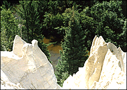 |
| The Nipekamew Sand Cliffs, located near La Ronge. |
Geological features they might learn about, in addition to Deep Bay, include: the 35-km-diameter Carswell impact crater, created more than 400 million years ago by a meteor that may have been a kilometre in diameter; the Wathaman Batholith area of crystallized magma, which was formed deep beneath a mountain chain about 1.85 billion years ago; and the beautiful but remote Athabasca Sand Dunes, created a mere 9,000 years ago when sandy deltas on the south side of Glacial Lake Athabasca were exposed to prevailing northwesterly winds. Those sandblasting breezes also produce curious two- and three-sided stones called "ventifacts", pictured on the map.
Maxeiner predicts Saskatchewan's varied geology will surprise some people.
"They'll see that there's a lot more to this province than wheat fields.''
The Geological Highway Map of Saskatchewan is free to all Saskatchewan school libraries and sold to the public for the same price as the provincial road map. The map can be ordered by emailing the Saskatchewan Geological Society. Discounts are available on bulk orders (multiples of 20 maps).
Contact Us
| Contents |
Advertising
| Archives
| Maps
| Events | Search |
Prints 'n Posters | Lodging
Assistance | Golf |
Fishing |
Parks |
Privacy |
© Copyright (1997-2012) Virtual Saskatchewan
|

