

by Dave Yanko
MISSINIPE — Almost an hour after leaving Missinipe on a motor-boat
tour of Otter Lake, the guide directed our attention to a small
section of the not-too-distant shoreline that appeared lower than
the surrounding land.
 |
| Sherri and Kira
enjoy their lunch at Robertson Falls. |
"That's the falls," he said, happily maintaining the throttle as
we charged towards the gap on the horizon. "If we kept going, we'd
go right over them."
I was expecting to encounter Robertson Falls from the bottom, rather
than the top. It's just the way I pictured it. Had I given it more
thought I would have remembered Otter Lake and the Churchill River
System that feeds it drain northeast into Hudson Bay. And we were
definitely headed east, into the warm morning sun.
Friends in a boat behind us trailed at a distance sufficient to
notice our eventual change in direction and speed, in spite of the
fact their attention was pinned to the sky in a search for more
bald eagles like the one Barry stopped to photograph a few minutes
earlier. This ecoregion
is home to the second-largest, bald-eagle nesting grounds in North
America.
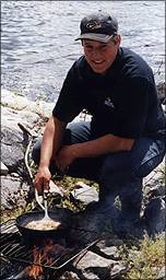 |
| Our guide Darren
preparing the shore lunch. |
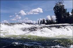
We approached the rocky Canadian Shield shoreline safely, just upstream and out of sight of the falls. After anchoring our boats, we grabbed our gear and set off on a 10-minute hike to the base of the rushing water we could hear and glimpse as we tromped down through the pines. We were moved by the splendour and power revealed at the end of the trail.
Robertson Falls is a beautiful spot where the water from Otter
pours down over three tiers of rock into Mountain Lake. Five kids
scrambled for their fishing rods and cast out into the swirling
water at the base of the small falls. And the kids filled the next
45 minutes with squeals and grins and walleye and northern pike.
Afterwards, our guide prepared a traditional 'shore lunch' of fresh
fish using a fire built on the rocks. It was a tasty and fitting
end to a fine morning on the Churchill. Afternoon brought more sightseeing,
fishing, and a journey up a small river to view first hand some
of the aboriginal rock paintings
that add a sense of mystery to this timeless land.
Some people spend a lifetime of summers exploring the Churchill's
lakes, streams and hundreds of islands. Most of them do it by canoe
- the Churchill River system is considered one of the finest wilderness
canoeing experiences in the world. Maps for more than two dozen
documented canoe routes are available at the park or from the provincial
parks branch in Regina.
Beyond the Churchill's rugged beauty, there's history; the river
system played an integral role in the fur trade 200 years ago. That's
when the colorful voyageurs canoed and sang their way through these
waters to trade for furs with the Wood Cree, whose descendants still
live and ply their skills here.
One afternoon I and several of the kids strolled from our campground
to the small beach at Missinipe, the adjacent village renowned for
its spirit and hospitality. The early-July water was still quite
cool. As I sat on the beach warming up under the sun, I watched
an Indian man in jeans and a light shirt stride down from a nearby
lodge towards the lake, where several aluminum fishing boats were
pulled up on shore.
It appeared for an instant as though he was going to walk right
past the boats and into the water. But as he drew up alongside one
of them his right hand caught its bow, and in what almost seemed to be one fluid motion
he launched the craft and hopped into it.
He stepped with confidence towards the back of the boat, where
he lowered the motor and pulled out the choke while taking his seat
on the back bench. Then he cranked the motor to life, punched in
the choke, adjusted his ball cap and goosed the throttle for the
tight U-turn that set him on course across the lake.
He'd probably done this a thousand times. His great-grandfather
was probably equally adept with a canoe.
 |
| View from a trail
in the park. |
Otter Lake is located within the boundaries of Lac La Ronge Provincial
Park, Saskatchewan's largest park and one of the few situated in
the Canadian Shield. The park was established in the 1930s. But
it wasn't easy to get to it until 1948, when a gravel road was constructed
from Saskatchewan's north-central City of Prince Albert to the Town
of La Ronge, on the shores of gigantic Lac La Ronge (La Ronge Lake).
Once the road was completed — it was upgraded to pavement in the
1970s — word spread fast of the breathtaking northern landscape
with an unparalleled freshwater fishing experience. The old gravel road became
a popular conduit for fishermen from across North America. So popular,
in fact, that some fishermen in the early 1950s were leaving La
Ronge with, literally, truckloads of fish, according to retired
Prince Albert bush pilot Earl Dodds.
Vastly-improved regulation of Saskatchewan's fisheries long ago
put an end to those fish-harvesting bonanzas. Today, the region's
healthy outfitting industry is testimony to the fact recreational
fishing remains one of the park's primary draws.
But while great fishing and canoeing are La Ronge's hallmarks,
the park's emphasis now is on attracting families and other vacationers
interested in experiencing the natural wonder of the southern Churchill
system — both in summer and winter. Staff are in the process of
upgrading facilities to better accommodate the type of visitor who
requires a few more amenities than perhaps — just perhaps — an all-male
fishing party.
Our group of four adults and five kids was delighted to discover
flush toilets and sinks (showers have been added since our visit) in the clean washrooms
at the small provincial campground (15 sites) at Missinipe.
(See the Saskatchewan Parks website for up-to-date information on campgrounds and amenities in the park.)
It's important to note pavement gives way to gravel just a few
kilometres beyond Wadin Bay. Travel to points north of there can
be a little rough and dusty (or messy, if it's raining).
If you prefer fixed-roof accommodations, there's a good variety
of hotels, motels, lodges and cabins for rent in and around the
Town of La Ronge, and there are cabins and/or lodges at Nemeiben,
Wadin Bay, English Bay and Missinipe.
Lac La Ronge Provincial Park can be enjoyed without a boat. But
I'd strongly recommend bringing a boat or canoe, or renting one
when you're here. The vast majority
of the park is simply inaccessible without one. Lac La Ronge, alone,
has 1,000 islands, most of them uninhabited wilderness
waiting to be explored. Or shore lunched.
Almost all the channels, rapids and waterfalls that link together
hundreds of lakes in the river system can only be reached by water.
A notable exception is Otter Rapids, 6 kms north of Missinipe, where
the mighty Churchill River is confined to a narrow channel for a
quarter of a mile.
 |
| Wispy ferns carpet
the forest floor near Nemeiben Lake. |
Otter Rapids is a popular spot with white-water canoeists, however,
pedestrians afraid of heights may find the steel-grid bridge that
spans it a little unnerving. I'm told, but I didn't see this myself,
that local kids actually hop off the bridge and 'shoot' the rapids
in their bathing suits. Apparently it's not uncommon for experienced
canoeists to ride the rapids in life jackets. But they hop into
the turbulence at water level.
The 25-metre (80-ft) Nistowiak Falls, one of most beautiful spots
in Saskatchewan, can only be reached by boat. And the same goes
for historic Holy Trinity Church at Stanley Mission, constructed
between 1854 and 1860. It's the oldest building in Saskatchewan.
Only by boat can you get to the portages used by the voyageurs
more than two centuries ago, where non-native saskatoon-berry bushes
along the path bear witness to the fact the voyageurs ate imported
pemmican without chewing all the berry seeds.
West of the park on an island in Sandfly Lake, explorer Alexander
Mackenzie around 1790 discovered a large boulder shaped like a bear.
According to Mackenzie's journal, local Indians painted a bear head
on the rock. But in more than 200 years, nobody's been able to find
the well documented 'bear rock'. One thing's certain: you won't
find it travelling by car.
I don't mean to leave the impression there's nothing to do in Lac
La Ronge Provincial Park if you don't have access to a boat. Fish
from the rocky shoreline of any lake and there's a good chance of
landing one of the northern pike, walleye or sauger that made this
area famous (you'll need to cast out really, really far, however,
for the lake trout).
Although lakes in the pre-Cambrian Shield are not generally noted
for their sandy beaches, the park features several decent ones.
One of the best is the south beach at Wadin Bay. There's a nice creative playground and barbecue pits, as well, making
it a good day-trip destination from just about anywhere in the park.
As part of the effort to attract families, the park is developing
more programming and activities for kids. On the Canada Day long
weekend when we were in Missinipe, for instance, our kids found
themselves riding shotgun on the village fire truck during the local
Canada Day Parade.
The whole day was a hoot, beginning with the free pancakes-and-sausage
breakfast at the Missinipe community centre and continuing through
the afternoon with games, competitions and prizes — as well as free
burgers and hotdogs — in the village park.
Canada Day celebrations in Missinipe ended with a birthday cake
and the traditional fireworks display on the beach, where even the
voracious northern mosquitoes couldn't spoil the fun. But don't
test the Bugs of the North. Take lots of repellent.
 |
| Water, rock, trees
and sky in Lac La Ronge Provincial Park. |
Lac La Ronge Provincial Park is the kind of place you discover
in pieces and layers. It seems unlikely that one of the first pieces
of Saskatchewan visited regularly by Europeans should remain one
of the most beautiful wilderness areas in the province.
Yet, those who've taken the time to explore the park know evidence
of those early visitors is everywhere, from the saskatoon-berry
bushes, to the portages, to the old and mostly hidden fur-trading
posts, to the colourful stories and characters associated with many
of the rapids, islands and lakes.
Underpinning this natural beauty and history are the Churchill
River rock paintings, a reminder this wild place was home to a people
long, long before Europeans came here. And it still is.
Contact Us
| Contents |
Advertising
| Archives
| Maps
| Events | Search |
Prints 'n Posters | Lodging
Assistance | Golf |
Fishing |
Parks |
Privacy |
© Copyright (1997-2012) Virtual Saskatchewan
|

